News
Green light to free child care funding in Denbighshire
The Welsh Government’s 30 hours a week funded education and childcare in Wales scheme will be introduced in the county in January 2019, with the whole county benefitting from the roll-out at the same time.
In 2017 the Welsh Government (WG) pledged to offer 30 hours a week of government-funded early education and childcare to eligible working parents of three and four year olds, for 48 weeks of the year by September 2020.
Children will be eligible to access the offer from the beginning of the term following their third birthday until the September following their fourth birthday.
Eligible children will be entitled to up to 20 free hours of childcare during term time, on top of the 10 hours already provided by the Foundation Phase. During the school holidays, when there is no early education, the offer will provide 30 hours a week of childcare for up to nine weeks. Parents are able to choose any registered childcare setting that suits their personal and family circumstance, whether inside or outside of county, in agreement with the provider and the local authority.
Those not currently accessing the 10 hours a week free childcare provided by the Foundation Phase will be able to apply for 20 hours free childcare, as part of the scheme.
To be eligible for free childcare, parents/ guardians must meet a set of criteria: their child must be aged 3 or 4; parents/ guardians work and earn the equivalent of at least 16 hours at national living wage or national minimum wage, or are in receipt of specific caring benefits and they must live in Denbighshire.
Information about the registration process will be publicised in due course. For further information, please visit: www.denbighshire.gov.uk/fis
Call for Candidate Sites: Local Development Plan
As part of its work on a new Local Development Plan, the Council is now inviting landowners, developers and any others with an interest in land in the county to submit suggested sites for future development.
The Local Development Plan (LDP) sets out where, and how much, future development will happen in the county, as well as the areas to be protected from development. To help inform these decisions, a ‘call for candidate sites’ will be held until 26th November 2018.
Submitting a site is not, however, a guarantee of inclusion in the LDP. All sites submissions must provide sufficient background information and the Council will assess each site before making a decision on its suitability. All sites selected for inclusion will be subject to public consultation as part of the Deposit LDP early in 2020.
Guidance and forms for submitting a candidate site are available on the Local Development Plan section of the Council’s website at www.denbighshire.gov.uk. All forms must be submitted in full, and accompanied by the necessary maps, before the deadline of 26th November. Incomplete or late submissions will not be accepted.
For further information, please contact the Strategic Planning and Housing Team:
Email – planningpolicy@denbighshire.gov.uk
Phone – 01824 706916
£18 million East Rhyl flood defence work plans go on show
The Council, supported by the Welsh Government's Coastal Risk Management Programme, has drawn up plans to install rock armouring and increase the height of the sea wall along the promenade between Splash Point and the slipway next to Rhyl Golf Club.
Construction is expected to take 18 months and start during 2019, subject to planning permission, other necessary consents being granted and funding agreement.
Residents will have the chance to view the plans and comment on them at a drop-in session on October 11 between 10am to 4pm at the Elwy Room, Rhyl Community Fire Station. A further event is planned for November 8 at the same venue.
The Council commissioned civil engineers Balfour Beatty and flood risk and environmental specialists JBA Consulting to undertake a detailed analysis of the situation to come up with the plans.
The rock armouring is being designed to dissipate the energy from storm waves so the impact on the new wall will be substantially reduced and significantly decrease the risk of flooding for over the next 100 years.
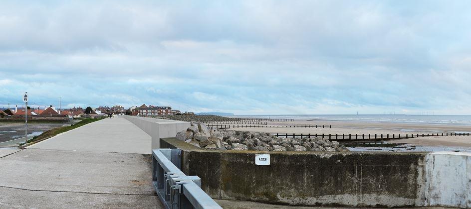 Photo of the site for the proposed flood defence work
Your view needed on changes to the boundaries of Rhyl Conservation Area
The Council has reviewed Rhyl Conservation Area and is proposing some changes to the boundaries. We are currently consulting on these proposals, which are outlined further below.
A Conservation Area is an area ‘of special architectural or historic interest, the character or appearance of which is desirable to preserve or enhance’
A conservation area designation is a way that a local authority can add an extra layer of planning control, to help protect areas which are valued for their special architectural or historical interest. The aim of Conservation Area Legislation is to preserve and enhance areas of our historic environment that hold value to the people that interact with them, in order that they are enjoyed by this and future generations.
Rhyl is a planned Victorian seaside town containing many Victorian and Edwardian buildings. Although it has been the subject of much alteration over the years in the form of inappropriate, low-quality buildings of unsympathetic design, there is still much to be celebrated in Rhyl.
Originally there were two separate Conservation Areas designated in central Rhyl with St Thomas Conservation Area designated in 1988 and Queen Street/Crescent Road Conservation Area designated in 1992. In 2007 it was decided to review both Conservation Areas in central Rhyl and combine them into one larger conservation Area. The current Conservation Area covers a broad area of Rhyl Town Centre from Abbey Road in the east to Bath Street in the west and from West Parade in the north to the railway station in the south. We decided that the Rhyl Conservation Area would benefit from a review as it was felt some areas had lost their character and it was a large area to manage.
The review recommended four main changes to Rhyl’s Conservation Area boundaries. In summary, they are:
- Extend the North-Eastern boundary to include the upper areas of Bath Street and Morlan Park.
- Remove the Premier Inn Development Site, Harkers Amusements and the Queen Street Development Site.
- Include the former Regal Cinema.
- Exclude the Coach Park/Proposed Car Park on Crescent Road and redraw boundary to exclude 20-30 and 11-23 Edward Henry Street.
We are proposing to change Rhyl’s Conservation Area boundaries in line with these recommendations and public consultation on the proposed changes will finish on 2nd November 2018.
Comments on the proposed changes to Rhyl Conservation Area should be sent in writing to The LDP Team, Strategic Planning and Housing, Denbighshire County Council, PO Box 62, Ruthin, LL15 9AZ or can be made online at www.denbighshire.gov.uk or by email to planningpolicy@denbighshire.gov.uk before 5pm on 2nd November 2018.


Manage your own Council Tax online
You can now manage your own council tax online. It’s free and easy to register! It will allow you to view details for:
- Council Tax
- Housing Benefit and Council Tax Support
- Landlord
- Business Rates
You can set up a payment plan to pay your Council Tax online and e-billing is easier and greener.
You can log on to:
- Set up direct debits
- Pay your council tax online
- Report a change of address
- Apply for a discount
- Find out how much council tax is at a property
To set up e-billing, please e-mail revenues@denbighshire.gov.uk. You will then be able to register to view your online account at www.denbighshire.gov.uk/counciltax.